


World Principal Mountains and Rivers, a comparative chart by Darton & Gardner, 1823 art print poster canvas gift
- High-quality product
- Perfect gift
- In stock, ready to ship
- Backordered, shipping soon
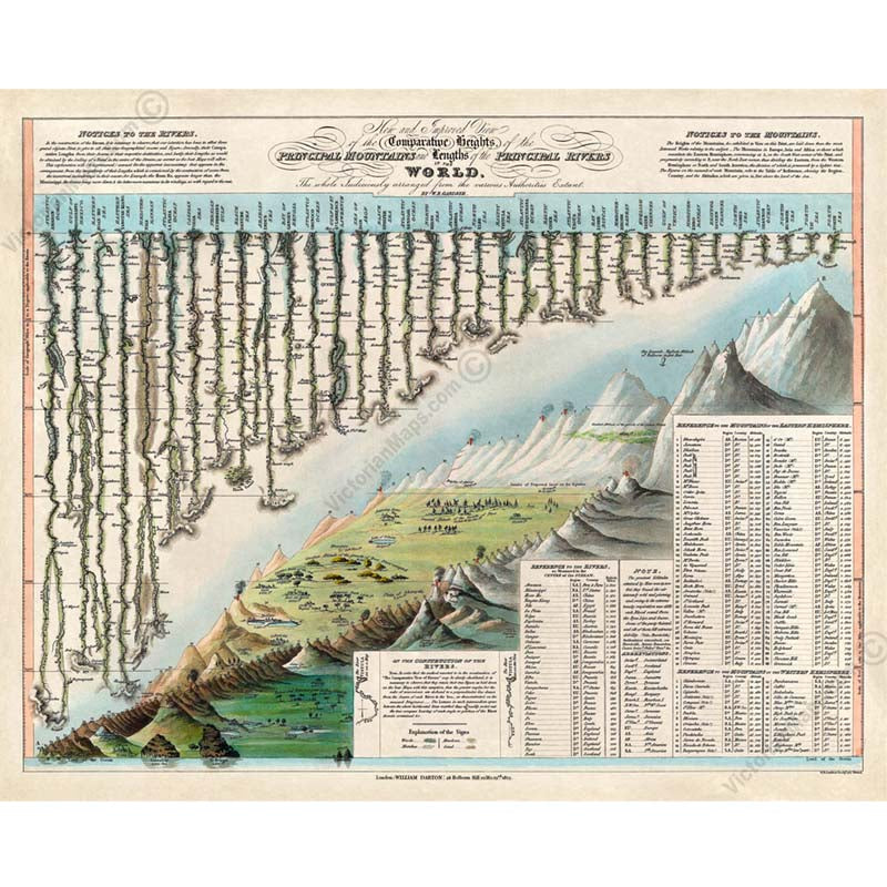
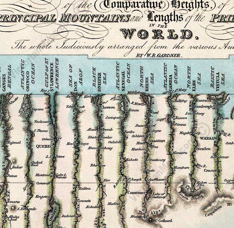
"New and Improved View of the Comparative Heights of the Principal Mountains and Lengths of the Principal Rivers In The World, The whole Judiciously arranged from the various Authorities Extant. By W.R. Gardner. London: William Darton, 58 Holborn Hill, 10 Mo. 23rd, 1823. W.R. Gardner Sculpt. 367 Strand."
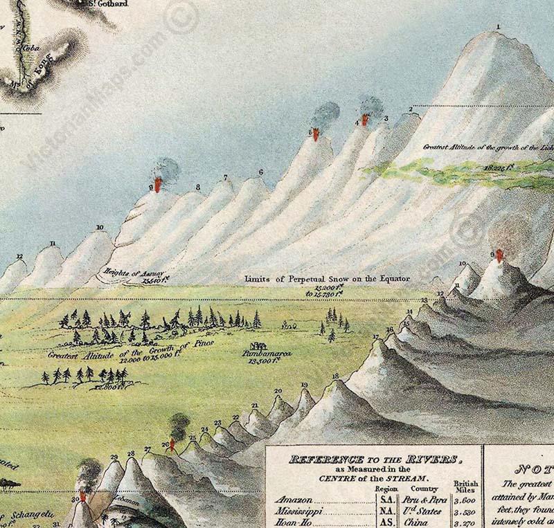
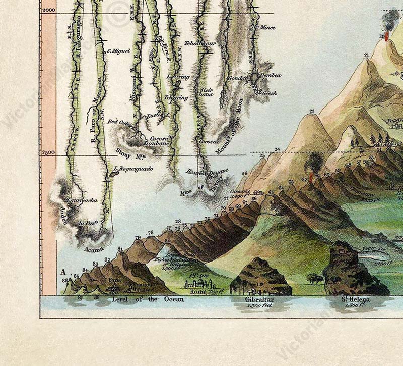
This chart by Darton & Gardner is the first known example of a comparative chart to depict both mountains and rivers in the same plate. This innovative cartographic style would flourish throughout the remainder of the 19th century. On the lower right is the comparative mountains section which details the principal mountains of the world. The peaks are colour coded to illustrate different types of vegetation and numerically referenced to the information tables below. The elevations of several principal cities are also included, as well as notations on vegetation and volcanic activity. Himalayan peak Dhaulagiri is identified as the world's greatest mountain. Also curiously noted the hot air balloon flight by Gay-Lussac in 1808 who reached the altitude of 7000 meters. The upper left part of the chart is dominated by the world's greatest rivers, together with notes to their course and sources, lakes, major cities & directions, and distance measurements. The Amazon is identified as the world's greatest river at some 3600 miles, followed by the Mississippi at 3530 miles. The original chart is extremely scarce.
William Darton (February 2, 1881 - July 28, 1854) was an English publisher and engraver active in Tottenham, London during the early part of the 19th century. Darton was the eldest son of William Darton Sr., himself a printer and publisher who co-owned the firm of Harvey and Darton. Darton, a Quaker, was educated at the Friends School in Clerkenwell, London and the Ackworth School in Yorkshire. Afterwards Darton apprenticed to his father where he mastered the part of printing and engraving. Around 1804 Darton opened his own shop, the "Repertory of Genius", specializing in maps, prints, children's books, educational publications, and other "works of merit" at 50 Holborn Hill, London. Cartographically Darton's most significant contribution is his 1823 publication, along with engraver W. R Gardner, of the first composite comparative mountains and rivers chart. Darton also published various maps for the 1802 Atlas to Walker's Geography and his own 1813 Union Atlas. Darton retired in 1851 leaving his business to his son, John Maw Darton, who partnered with Samuel Clark and published as "Darton and Clark".
William R. Gardner (fl. c. 1810 - c. 1850) was and English engraver active in London during the first half of the 19th century. His offices were at 867 Strand Street, London. Gardner worked with many of the most prominent London publishers of his day including Charles Smith and William Darton. His most significant contribution to the world of cartography is his 1823 publication, along with publisher William Darton, of the first composite comparative mountains and rivers chart.
This poster is a high quality "giclée" reproduction of a restored antique original, custom-printed on Standard Single-weight Matt Coated art paper 140gsm or Heavyweight Matt Coated art paper 230gsm (more of a thin card density), or superb Epson Matt Canvas 320gsm, according to your choice. We use the latest UltraChromeHDX pigment inks which guarantee 60 years of colour permanence (up to 200 years fade-proof for colour prints). This poster is suitable for mounting and framing, as well as direct display on a wall.
This high-resolution, museum-grade fine art print is produced from a unique restored image. Printed on premium archival-quality art paper or canvas, it makes a striking addition to any interior as wall décor or a poster, and a memorable gift for lovers of antique and vintage maps, collectors of historic prints, historians, and explorers. Almost indistinguishable from the original Georgian engraving, it adds character and interest to a study, library, or office wall. It also makes a thoughtful gift for all occasions, including Christmas, Valentine's Day, Easter, and Father's or Mother's Day.
All prints are made to order and carefully checked before posting. Our restored charts and maps are exclusive to VictorianMaps and not available anywhere else. There are no watermarks on the prints.
Combined shipping available—add all items to your basket to see the adjusted rate. Any extra postage paid will be refunded.
Returns:
If you're not satisfied, return within 14 days for a full refund.
For framing, we recommend the 230gsm paper or 320gsm canvas. The 140gsm paper is best for DIY framing or wall tacking.